
IELTS WT1 (Map)
The map below shows the changes in an American town between 1948 and 2010.
Summarise the information by selecting and reporting the main features and making comparisons where relevant.
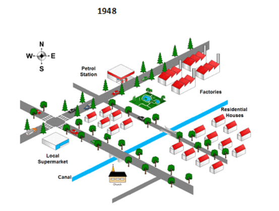
The supplied illustrations present changes in an American town from 1948 to 2010.
Over the given period of time, the town has witnessed big changes especially to the industrial area which was redeveloped. Government also constructed an airport and a sports stadium.
As can be seen from the map, four factories in north-east were demolished and an airport with three commercial buildings were developed in that area. Petrol station to the west of factories and all north-west side of the town, however, remained untouched.
Government replaced a part of residential houses in the centre of the town with two commercial buildings, and the other 11 houses in the south-east did not change. Local supermarket in the west was removed to the area near factories where a park once stood. Old supermarket’s area was also made into two commercial buildings. Sports stadium was set up in south of the town next to a canal.
by Zhanel Dorzhigulova
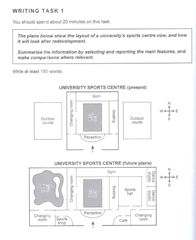
The maps represent the plan of university sport centre at present time and the improved future plan.
Overall, the sport area will experience the development of infrastructure with the building of extra rooms on the outdoors courts’ territories and the extension of the gym as well as changing rooms.
Outdoor courts are situated on the west and east sides of the centre, but in future it is planned to be replaced by the leisure pool on the west and sports hall on the east. Moreover, the east wing will additionally get two dance studious. The other improvements are taken place in the reception area: on the right side, there is going to be a cafe and on the left side, the sports shop will be located.
The extra space will be added to the gym and changing rooms sections. While the gym will spread to the east, ending up the front of the dance studio, changing rooms will be set up in two more locations in the south part of the university sports centre. First one is planned to be in the south of leisure pool in the right corner of the plan, neighbouring the sports shop, and second is going to be on the right hand from the cafe.
by Olga Kotenko
The maps below show the town of Langley in 1910 and 1950.
Summarise the information by selecting and reporting the main features, and make comparisons where relevant.
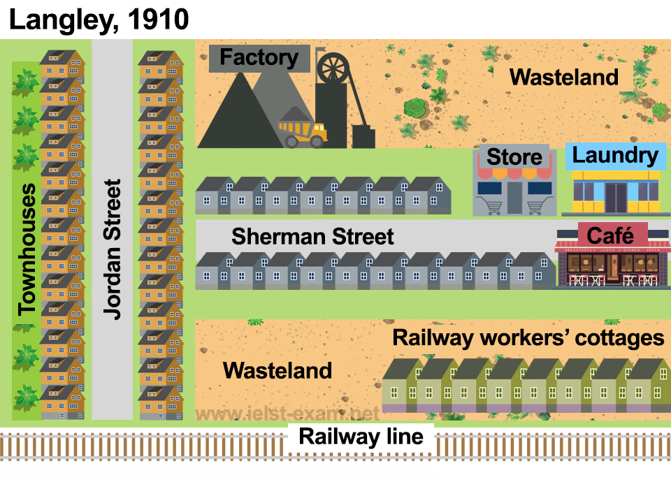
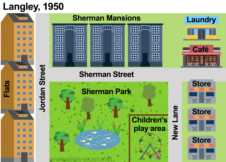
The illustrations represent a development process of the town known as Langley from 1910 to 1950.
Overall, although some places stayed almost the same, the town experienced dramatic changes in industrial spheres and residential facilities.
First of all, the old factory in the north part of the city was totally demolished and replaced with three identical four-storeys buildings of Sherman Mansions. The townhouses which lied on the both side of Jordan Street was converted into the exactly the same three 6-storeys flats on the left of the street. In contrast, the buildings on Sherman Street were knocked down completely. The new Sherman Park with a man-made lake in the centre, children’s play area in the south-east and with a lot of green spaces were introduced in the one of the wastelands. The railway line nearby this wasteland was removed in 1950.
As can be seen, laundry and café remained unchanged, despite their locations. In 1950, café was moved to the opposite side of Sherman Street and laundry was placed just behind this café covering the second wasteland in the north east of the city. A store, on the other hand, was extended into three stores along the New Lane which was also erected in Langley.
by Gulmira Kinzhekeyeva
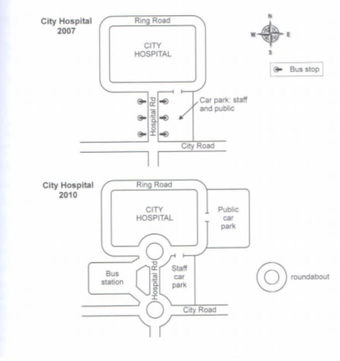
The plan illustrates the changes in the environment of City Hospital which took place between 2007 and 2010.
Overall, the road infrastructure was substantially developed. The joint parking for visitors and hospital staff were divided into two detached facilities. The bus station was relocated to a separate bay and the road was enhanced with two roundabouts.
In 2007 the scheme of the area around City Hospital was simple. The main building was surrounded by Ring Road. Hospital Road went from the hospital entrance to the southern direction and crossed City Road. The bus stations were situated on both sides from the Hospital Road, and the small car park was located on south-east from the Hospital.
In 2010 two roundabouts appeared, connecting Hospital Road with City Road and Round Road. The new public car park was built on the east, therefore old park is now used for internal hospital needs. Huge bus station appeared in front of the clinic, attached with Hospital Road by two driveways.
by Alesia Leschinskaya

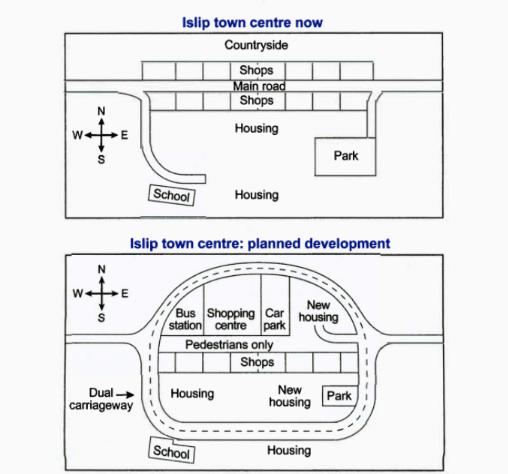
The two layouts illustrate the centre of Islip town at present and its proposed future changes.
Overall, the main road is planned to be redevelop into a roundabout with dual carriageway and some commercial as well as accommodation facilities being added.
Islip town now has a countryside up to north and the main road that crosses the centre. On both sides of the road there are some commercial facilities such as shops. Houses are located in the middle and to the south of the town. School is constructed next to the south houses. In the south-east side, park is built.
Regarding the proposed changes, countryside is to set to be removed and park territory will become smaller. Housing areas will be moved to the west-side and to the south-east. New residential facilities are planned to be constructed inside the roundabout. Shops on the south part of the main road will remain and in the north, a shopping centre is to be constructed. Bus station and a car park will be introduced and located in both sides of the shopping centre. Pedestrian crossing is planned to be next to the shops.
by Daniya Bekentaeva
The maps below show the centre of a small town called Islip as it is now, and plans for its development.
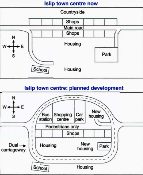
The maps display the current layout of the center of a small town, Islip, and how it is planned to develop.
Overall, the town center is to be brought up-to-date, with the construction of some modern facilities and more housing.
There is a main road running east-west through the town center. This road has two side roads, one leading to the school southwest of the town center and the other to the park in the southeast. While the main road is to be pedestrianized, the two side roads are to be turned into a dual carriageway, extending to the countryside north of the town center.
All the shops north of the main road are to be demolished to make room for a shopping center, which is to have a car park and bus station nearby. There are also plans to build some new housing northeast of the main road.
To the south of the main road are some shops and housing. The shops are to remain unchanged, whereas the housing is to be relocated. Lastly, some parts of the park are going to be cleared so that new residential buildings can be built, and an extension is planned for the school.
by Bekassyl Adenov
The maps below describe an area before and after the construction of a hydroelectric power plant.
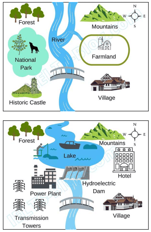
The two diagrams demonstrate how a territory looked before and after constructing a new hydroelectric power plant.
Overall, what stands out from the map is that with a new power plant, National park and Historic castle will be converted into Power Plant and Transmission Towers. Moreover, River will be extended as a Lake.
As can be seen, National park with flora and fauna and Historic Castle will no longer be on the west of the area, instead Power Plant and its Transmission Towers will be built. River with two ways will be combined and become a Lake where people can fish and sail. Another noteworthy change is that Farmland will be demolished and developed into a Hotel on the northeast of the Lake. Hydroelectric Dam will be constructed on the northern side of the bridge. Forest on the north-west and Mountains on the north-east side of the river will not see any changes as well as the village on south-east of the bridge.
by Aigerim Bekbolatova
The maps demonstrate the current plan of the center of a town called Islip and how it will look in the future.
Overall, it can be noticed that roads in a shopping area will be completely removed and replaced with a pedestrian zone. Moreover, housing and shopping are planned to be framed by new roads for vehicles.
First of all, small shops in the north are expected to transform into big shopping center, with a bus station to the west and a car park to the east. New housing is planned to be built in the north-east side of the center. Additionally, main road in the commercial area in the north is projected to be removed and pedestrianized.
It is obvious that dual carriageway that will go around the city center is planned to be constructed. Consequently, the area of a big park to the south-east is predicted to remain smaller in the future. New housing in front of the park will also contribute to this change. Small shops in the center of the town and school on the other side of the road to the left corner are expected to stay untouched.
by Adina Zhorobekova
Proposed modifications to Islip town's central precinct include the construction of neighboring roundabouts in the center and the following foundation of residential and commercial units.
The current map of Islip shows one major road running from west to east through the center of the town. However, according to a proposed diagram, this road will be transformed into a pedestrian-only area expanded by capturing all current shops on the main road. Shops on the northern side of the new pedestrian thoroughfare will be removed to make way for a bus station, shopping center, parking lot, and doubled housing in residential areas. The shops on the southern side will remain, although the town's park might be smaller to provide space for more housing units within the ring road.
Meanwhile, a two-lane expressway is planned to redirect vehicle traffic around the outskirts of the township, making the destination more pedestrian-friendly, especially for school and housing zones.
by Alima Almadiyeva